

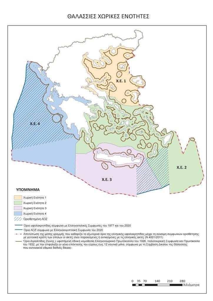
Marine Spatial Planning. The first step for the Greek Blue Homeland.
Map source: internet.
Finally, the Greek Government, on Holy Wednesday, April 16, 2025, announced, after a delay of more than a decade, the NMS. For the first time, Greece sets the rules for the organizational structure of the National Maritime Space and essentially ensures the management of its wealth. With the NMS, our country regulates sustainable tourism development, the improvement of maritime transport, the proper exploitation of its energy resources, fishing spectacles, fish farms and other related issues. The aim of this article is to try to decipher, as much as possible, all its points, so that the importance of the NMS is understood and where there are black spots, to highlight them, with the aim of correcting them, so that they cannot create diplomatic footprints on the other side of the Aegean.
What is Marine Spatial Planning and what is its goal?
The MSP essentially delimits all activities that can be carried out within the boundaries of our maritime zones, without overlooking the protection of the environment and at the same time specifying all those actions that aim at the sustainable economic development of the seas and the island complex, exploiting all marine resources. What is the goal and why should a coastal country have a Maritime Spatial Planning? A MSP organizes in the best possible way all maritime activities that can take place within the zones delimited by it, taking into account also the land activities that affect the maritime zones, such as social, economic and energy activities, with a view to protecting the environment. Let us now see what this regulation includes, as reflected in the official announcement of the Ministry of Environment, which I am posting here.
- The protection of the marine environment from the impacts of climate change and the designation of marine parks.
- The preservation of our cultural heritage and especially underwater antiquities.
- The improvement and protection of maritime transport.
- Sustainable tourism development.
- The exploitation of the country's energy resources, especially the potential natural gas deposits and our offshore wind farms.
- Fish farming.
- The strengthening of cross-border infrastructures of common interest with other member states of the European Union and its immediate region.
Why does the EU need the MSP?
As is known, the submission of the Maritime Spatial Planning map was made after unbearable pressure from the European Union and took shape after the recent condemnation of Greece by the European Court of Justice for its failure to submit it. This condemnation came, not because Greece simply did not deal with an issue that serves our National interests, after all, the EU suddenly did not feel the pain, for issues of Greek National Sovereignty, but because for the EU, the establishment of the MSP serves its own development interests and thus pressured Greece, even reaching the point of condemning it and imposing a fine, because it did not proceed with its submission. But why was the EU "burning" over the submission by our country of the MSP? Because quite simply, for a decade now, the EU has set some development goals, which will be "unfolded" within the maritime zones of its territory, and without the existence of the MSPs by the member states, this planning cannot be completed.
What does the EU provide for countries that have problematic and delinquent neighbors?
The main concern of the EU member states was what would happen if a member state during the MSP deposit, would have the full support of the EU, if its neighbor is problematic and delinquent. The EU's provision on this issue is completely problematic and this is because it explicitly and categorically states that the EU will NOT have any involvement in the case of resolving interstate disputes, even if the delinquent state is NOT a member of the EU and simply refers to what the International Law of the Sea describes for these cases!!! This practically creates a huge problem for a country like Greece, due to Turkish revisionism and the presence on the part of Turkey of the threat of casus belli, i.e. the cause of war, for such actions. Here, all the Greek parties that have members in the European Parliament should take the necessary actions, so that this European logic changes and the competent European Commissioner, Andrius Kubilius, should propose, first to the Council of Defense Ministers and then, to the Union Summit Council, the change of this logic and to pass it into Union Law, that the EU will guarantee politically and militarily, any hostile actions taken against a member state that attempts to implement the Community directive on MSP and EEZ, so that all member states are covered, from any danger that may arise.
What is the map of Seville?
Every time there is talk about our national sovereign rights, whether it is called MSP or EEZ, there is always reference to the Seville map and all discussions are based on it. But what does the Seville map describe and what is its diplomatic significance? This map is the study of a Spanish University in 2004, with EU funding, which depicts the EEZs of the EU member states, based on the logic of a maximum distance of 200 nautical miles, from each coast of the member state, to another and in the case where a coast is below this limit and enters the EEZ of the other state, then the logic of the median line is applied there. It is worth noting here that the EU, in addition to funding this study, asked the member states, which had maritime territory, to send the maps with their own mapping of the EEZ and based on them, the university proceeded with its own final study. When sending the request to the member states, the EU pointed out that what will result from the study of the Spanish University is NOT binding and does NOT constitute a diplomatic fait accompli. Thus leaving "open the back door" of the questioning of European sovereign rights by third countries that have NO relation to the EU, something that Greece has found itself facing today, mainly with Turkey, but also with Egypt, which did not close the issue of EEZ delimitation with Greece, pretexting Turkey's refusal.
What do we see reflected on the MSP map?
Naturally, such conditions are accompanied by maps that reflect what is being signed and to which areas these signatures refer. So in this case, the Greek Government, together with the MSP, published the necessary map. But what do we really see reflected in the deposited map of the Marine Spatial Planning? I will try to give the answer to this question below, in as simple words as possible, so that everyone can understand what is happening or what can happen, below, if of course the intention of the Greek Government continues to proceed with all those steps required to complete the entire project. Always hoping that this intention exists.
- The different colors we see on the map are purely for practical reasons, which, according to the Ministry correspond to the administrative structure of the Regions of the Country and nothing more. I write this so that the reader's mind does not go to the bad. The division of the Regions could be done on the logic of which Regions "see" the sea and this because they will be called upon to prepare the basic plans on the MSP, according to the model of the Republic of Cyprus.
- We see that the MSP was made on the basis of the Greek EEZ as defined by the International Law of the Sea. This of course does not constitute a reservation of an EEZ, and this is because the EEZ of each state is determined after talks and consultations between the contracting neighboring states at sea.
- We see that the Greek EEZ abuts the Cypriot one, which means that the island complex of Megisti, see Kastelorizo, exerts full influence, something that Turkey is fighting. This, of course, should soon be sealed with signatures for the conclusion of an EEZ with the Republic of Cyprus, so that it can be legally secured, with the submission of coordinates for the determination of the EEZ of Greece - Cyprus, to the UN. Here, the Greek and Cypriot governments should move immediately to finally resolve the issue.
- Where we see a continuous line on the map, as well as a diagonal line within it, it means that an EEZ has been demarcated with the neighboring country. Where this line is broken, it means that there is NO EEZ demarcation with the neighbor and for this reason, you depict the map with the "definition" of the EEZ, in the logic of the median line. In order for the reader to understand what the logic of the "midline" is, we should say the following. The logic of the median line is, as stated in the International Law of the Sea, the geographical intermediate point between two coastal states, which have interests in the same maritime space and does NOT constitute De Jure, but De facto, i.e. temporary boundary recognition point. De Jure, that is, permanent, occurs after consultations between the contracting states.
- With a more careful look at the map, the reader notices that while we have NOT demarcated an EEZ with Turkey, nevertheless, in the Dodecanese region the line, from the height of Samos and further southeast, is continuous, which refers to areas that have a demarcated EEZ. This is because Greece considers the maritime boundary delimitation agreement, which was signed between Italy and Turkey in 1932, when the Dodecanese were still part of Italian territory, to be active. This practically means that it can be used as a fait accompli by the Greek side for the alleged islands of the Greek-Turkish border, in future consultations with Turkey for the demarcation of the EEZ. Something that constitutes a very powerful diplomatic and, by extension, legal document for Greece.
- Also on the map we see that the islands of the Greek-Turkish border, further east, have little influence. This is because this is how it has been determined by the Treaty of Lausanne. The said Treaty did indeed determine 6 nm for Greece and 3 nm for Turkey, but under the condition that in the case where there were areas that were geographically closer to each other and the distance between them was smaller, such as for example in Samos, where one coast from the other is less than 2 kilometers away, then the maritime border between the two states is determined in the logic of the median line.
So based on the above, the map and the boundaries that emanate from it, in an official way, defend, to a certain extent, our National Interests and exert double pressure on the Turkish side, one at a diplomatic level and one on the ground. This is because the MSP is now a European acquis and essentially forms part of European legislation and sovereignty, putting, theoretically at least, in the game of defense, the entire EU.
Positive points of Marine Spatial Planning.
Among the positive points of the Marine Spatial Planning, beyond its submission and its formulation on paper, we should note the following three points.
- The demarcation of the demarcated EEZ at two points, with Italy and half with Egypt. This point, although with relative responsibility of Cairo it is half, should be closed immediately and to do this, the pending demarcation of the EEZ with Cyprus should be closed. This was the Egyptians' justification for demarcating half of the EEZ.
- The mapping of the potential EEZ with Albania, as agreed with Albania, back in 2009, which was later deemed unconstitutional by the Constitutional Court of Tirana, following an appeal by the then opposition of the current Prime Minister Edi Rama. There was a Turkish finger here and for this reason the Greek side is right to map it, for understandable reasons.
- The mapping of the potential EEZ with Libya southwest of Crete, in the logic of the median line, is something that has been respected by the pro-Turkish government of Tripoli itself, which a short time ago did the same and essentially with this move is reversing, in the right direction, the signature it placed on the illegal Turkish-Libyan memorandum.
Problematic points of Marine Spatial Planning.
- Plans have not been prepared that cover the range of activities that can take place within the THS zones, as reflected in the 7 points announced by the Greek Government. This could potentially be a problem for the lifting of the fine imposed by the EU on our country for the lack of a THS.
- What we see on the map is not a binding text, and this is because in any case, in order to be completed, it must be accompanied by the closure of the EEZ, so that our country can fully exploit the possibilities offered by the completion of the MSP and the EEZ.
- For its completion, Regional Plans must be prepared, analyzing the initial seven points. This will require quick work from the Regional Units and relative pressure from the competent services of the Ministry of Union Affairs, to accelerate the procedures.
- The fact of the disconnection, on the part of the Greek Minister of Foreign Affairs, Mr. Gerapetritis, of the Greece - Cyprus - Israel electrical interconnection pipeline, from the MSP, can be characterized as a problematic point.
- Lack of presence in the planning of artificial island complexes, with the aim of unifying joint actions.
- Nautical miles and EEZ. In the MSP mapping map, we can see a dichotomy. This dichotomy consists of the fact that the islands of the Ionian Sea are mapped with a territorial sea that reaches 12 nm and the islands of the Aegean are mapped with 6 nm. Another problematic point is the fact that the map is not accompanied by a filing of coordinates and especially in areas where an EEZ has NOT been demarcated with neighboring countries, this can be a potential problem.
- Another problematic point in the announcement by the Ministry of Environment and Energy, which in my humble opinion should be corrected immediately, is the use of the term "continental shelf".
What needs to be done to solve the problem?
In order to solve the current and future problems that may arise, but most importantly, to be able to utilize them diplomatically in the future, we must:
- To redefine, on paper, the separation that is made based on the administrative structure and the South Aegean Region to be separated from that of Attica, with which it has no economic and social connection, and either to form a separate part of the MSP, or to be unified with the Region of Crete and to prepare a common MSP since they have, if not common, certainly greater economic and social connections.
- MSP plans should be prepared immediately, both for the maritime area of the Region of Crete and the Region of the South Aegean, with a full description of the permitted actions that govern a properly formulated and designed MSP. I mention these two regions for two reasons. 1. Because these Regions have enormous economic-tourism potential and are culturally connected to each other and 2. Because they are the ones that define an EEZ with Libya, see Crete and "lock an EEZ with Cyprus and the rest that remains with Egypt. Putting an end to the Turkish dream of the "Blue" Homeland" and establishing in the best diplomatic way the one and only Blue Homeland, which is the Greek one!!! Then, let's proceed to develop plans for the entire MSP, so that each potential investor knows in advance what is allowed to happen and can thus proceed more quickly in preparing their study, for the development of points of interest and essentially the area where they want to invest.
- Immediate resolution of outstanding issues regarding the closure of the EEZ, with states that share maritime borders and where diplomatic understanding can be reached, such as Cyprus, Egypt and Libya. I also include Libya, because this state recently announced a competition for expressions of interest for the exploitation of marine energy plots that belong to it, RESPECTFUL the logic of the median line with Greece and thus essentially abolished the illegal Turkish-Libyan pact on the ground, something that Greece should immediately take advantage of diplomatically and Mr. Gerapetritis should hurry to close the issue of demarcating an EEZ with Libya and thus, by submitting the relevant coordinates to the UN, put a tombstone on the Turkish appetites once and for all.
- Regarding Gerapetritis' statement, with which he disconnects the electrical interconnection from the MSP, I should point out that the Greek Minister of Foreign Affairs is making a huge and tragic mistake, and this is because one of the uses of the MSP, as we said above, is the numbering of energy issues within this zone. So the pipeline must be built yesterday!!!
- "Creation" of artificial island complexes. The aim of this "creation" is, 1. The joint cultural and tourist exploitation, as foreseen by the MSP. 2. For their military exploitation, within the framework of the program announced by the Minister of Defense, Mr. Dendias, for the "Achilles Shield", thus providing another multiplier of deterrent power and security to our Country. This of course presupposes the involvement in the entire project of preparing the explanatory plan AND of the Ministry of Defense.
- Nautical miles. In this matter, our country should move methodically in the following way. In the Ionian Sea, as we said, the extension to 12 nm has been made. In the Aegean islands, which are a special case, a visual mapping of the future 12 nm of the territorial sea should also be made there, even if their delimitation has not yet been made, and this for two reasons. A. This map will be submitted to the EU and the UN, which makes it an official map mapping sovereign rights and therefore can be used in the future. B. So that it does not become an object of exploitation by Turkey, saying that after you submitted these 6 nm coordinates to the EU and the UN, then you accept the fact as a fait accompli and essentially you do not have the right to expand. As for the submission of coordinates, which show the limits of the Greek EEZ, they should be immediately included in the MSE file, since the entire project has been reflected on the potential map of the EEZ and this is to ensure, although it is not binding, future negotiations with the neighboring countries where the issue is pending. Here, to be fair, I should note the following. In the memorandum accompanying the MSE map, there is talk of the future expansion to 12 nm in the Aegean, but it would be good to also have a visual representation on the map, for purely diplomatic reasons, and this is because everything in diplomacy, except for documents, is also reflected on the maps that accompany them.
- The use of the term "shelf". This word should be immediately removed from the official declaration and this for the following National reason. This word has been our main conflict with Turkey for decades. What does the Turkish side say? The Turks say that the islands of the Eastern Aegean Sea lie on the continental shelf of the Turkish Mainland and thus have NO right to an EEZ, since they are a natural continuation of Turkish territory. The use by our side of this word may, not to say definitely, be the subject of diplomatic exploitation by the other side, with the aim of harming our national interests. It should be immediately replaced with the phrase "the limits of the Greek EEZ, as defined by the D. D. t. Th. and thus there will be no diplomatic "stepping" by the other side. To make what I am saying understandable, the Law of the Sea, since it was established in 1982, speaks of an EEZ and not a continental shelf, in order to avoid conflicts between neighboring states, with island complexes and coasts that are very close to each other, as is our case with Turkey.
Concluding this analysis, I must point out what in my opinion the Greek Government should do, in order to capitalize and make the most of this first, but important step in defending our National interests. We said at the beginning that the MSP does not constitute a guarantee of an EEZ. This practically means that the Greek Government should immediately: 1. Proceed with the delimitation of an EEZ with Libya, with the aim of De Jure also abolishing the illegal Turkish-Libyan pact. 2. Proceed with the delimitation of an EEZ with Cyprus, for the De Jure defense of the full influence of Kastelorizo in the EEZ. And 3. To close the pending issue with Egypt, regarding the remainder of the EEZ delimitation, and this is because in the event that something happens and the current government in Cairo changes, we do not know what will happen in the matter of closure, such a serious and vital issue for us.
All of the above, as is natural, will provoke a reaction from Turkey, and this is because with these moves that Greece is making, it is destroying the narrative of the "Blue Homeland" and this, as is natural, is causing irritation among the neighbors. At this point, the Greek Government should be ready for every eventuality and for every scenario that may unfold in the coming period, from the Turkish side, whether this is at a diplomatic level, or on the ground in the Aegean and Cyprus. Greece, in addition to what I mention that it must do at a diplomatic level, should have its eyes and ears open and maintain its deterrent power at a high level and be ready to respond to any challenge, which the other side is more than certain to make.
Athanasios I. Demetriades.
Member of the Hellenic Institute for Strategic Studies.
(EL.I.S.M.E.)